

- Details
- Category: Dissertation Defence
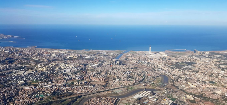
Maxime Colomb is defending his PhD thesis entitled "Multi-scale simulation of realistic forms of residential development from the parcel to the metropolitan area".
The defense will take place at the Université Paris Est, in the IGN (Institut Géographique National), 73 avenue de Paris, Saint Mandé on September 27th, 2019.
This work was directed by Julien Perret, Senior researcher, IGN (French national Geographic Institute) and Cécile Tannier, Senior researcher at CNRS (French National Centre for Scientific Research), Laboratoire ThéMA and co-directed by Mickaël Brasebin, Research Officer, IGN.
Defense jury
Cyrille Genre-Grandpierre, Professor at the University of Avignon, France
Jacques Teller, Professor at the University of Liège, Belgium
Hélène Houot, Lecturer at the University of Franche-Comté, France
Florent Le Néchet, Lecture at the University Paris-Est, France
Abstract
The process of urban sprawl of urban agglomerations is very often criticised for numerous reasons. The dynamics of residential developments, at the origin of urban sprawl, are very complex and result from the interaction of several phenomena. Many laws and regulations are supposed to control the construction of buildings in order to limit the negative impacts of urbanisation. It is nevertheless difficult to anticipate the effects of such a regulatory corpus. Its multi-scale nature, related to the different levels of regulation, the different regulated subjects and the different parties executing those regulations complicate the forecasting of their effects and the spatial configurations they contribute to create.
Here, we propose a simulation model for the residential development of an urban agglomeration. It produces realistic configurations respecting the orientations, goals and constraints stemming from urban planning documents. To that end, we elaborate a coupling of two existing spatial simulation models. This coupling, named ArtiScales, follows a top-down approach in simulating the shape of the residential development of an entire study area by selecting the constructible parcels and by simulating the construction potential of each plot. ArtiScales integrates the MUP-City model, that allows us to select interesting locations with respect to the built configuration of the study area and to several points of interest (transportation networks, shopping facilities, services, etc.). We develop a parcel management model in order to select the existing parcels interesting for residential development and to recompose them when needed according to the chosen scenarios and to specific situations (densification, special operations). Finally, we use the SimPLU3D model to simulate the constructibility of each parcel. This model generates spatial configurations, in three dimensions, respecting the regulatory constraints originating from the local urban planning scheme (Plan Local de l’Urbanisme - PLU). We concentrate the analysis of the coupling results on the estimation of created housing units and its agreement with the goals defined by the local housing program (Programme Local de l’Habitat - PLH) and on the housing density by hectare and its agreement with the goals defined by the territorial coherence scheme (Schéma de Cohérence Territoriale - SCoT).
Spatial simulation models are subject to an important variability that questions the reliability of simulation results. MUP-City being particularly subject to such variability, we conduct a complete analysis of its simulation results in order to caracterise the parameters responsible for this variability and how it translates to the produced spatial configurations. We distinguish two types of variations : the ones caused by scenaristic parameters, allowing to simulate different residential development forms, and those caused by technical parameters (internal to the model), allowing to propose variants of the scenarios. The variability between the variants is compared with the variability found in the study of MUP-City results in order to see if the model coupling absorbs or amplifies it.
The ArtiScales model (https://github.com/ArtiScales/ArtiScales) is available as free and open source software and can be used in many applications. A set of simulations representing different scenarios has been explored on the Grand Besançon territory (East of France). Simulations carried out represent a potential for residential development conforming to all the regulations at work. We also propose simulations that modify the zoning authorising the construction or not.
- Details
- Category: Dissertation Defence
Badra Merrad Benyamina is defending her PhD thesis "Space Movements and Mutations in Algiers" in Dijon
The defense will take place at the MSH of Dijon on July 1st at 14h30.
This work was directed by André Larceneux, Emeritus Professor at the University of Borgogne and co-directed by Tahar Baouni, Professor at the Ecole Polytechnique d’Architecture et d’Urbanisme (EPAU-Alger), laboratoire VUDD
Defense jury
Corinne Blanquart, Director of Research at IFSTTAR,Planning, Mobilities and Environment Department
Marie-Hélene Massot, Professor at the University Paris-EST Créteil, LAB’Urba
Thomas Thevenin, Professor at the University of Bourgogne, Laboratoire ThéMA
Abstract
Algiers port and city’s exceptional history is driven by its remarkable site nestled on a rocky spur. Yet this morphology constrained the urban growth of a city that could pretend joigning the ranks of large metropolis .During its history port and city relationship took multiple forms, frequently compatible yet sometimes divergent and even opposed, leading to inversing domination status of both actors. Algiers capital of a 40 million inhabitants state, has always been a laboratory of urban politics since the colonial era to the institutional constructions of independent Algeria, regardless of deficient statistical tools. However, the space in Algiers is confronted to great challenges due to an anarchic growth of its population, fragmented urban spaces and unbearable motion constraints. If road and collective transportation infrastructures are growingly programed and achieved by successive plans, their articulation with built-up areas and housing developments with the aim of eradicating slums does not seem to be really coherent. Furthermore, the location of communal amenities which seem to be relating to real estate opportunities, adds to the complexity of the urban fabric. However, under this apparent complexity, arise deep urban logics that should be highlighted and modeled.
- Details
- Category: Dissertation Defence
Valentine Judge is defending her PhD thesis "Machine Learning for Land Use Change Analysis and Modelling. An exploration of urban development on the French-German border area"
The defense will take place in Besançon at the Salon Preclin, UFR SLHS on July 16th at 3pm.
This work was directed by Jean-Philippe Antoni, Professor at the University of Borgogne, laboratory ThéMA and co-directed by Olivier Klein, Associate researcher at the LISER Institute, Luxembourg.
Defense jury
Francisco Escobar, Professor at the University of Alcala, Spain
Giovanni Fusco, Associate researcher "HDR" at CNRS, France
Guy Engelen, Emeritus researcher VITO Institute, Belgium
Bernhard Köppen, Professor at the University of Koblenz-Landau, Germany
Abstract
Urban development can take different forms or features, depending on its geographical location and its socioeconomic, political and cultural context. Nevertheless, the overall action relies on one fundamental principle: building construction in order to give people housing. Therefore, the main objective of this research is to determine whether an underlying universal aspect of the urban development process can be distinguished from a specific one, being the reflect of local specificities. Specifically, this research analyzes the land use change on the French-German cross-border area. Indeed, the border context enhances the difference within this territory. Nonetheless, the internal European border importance as a separation is getting lower while European Union agreement and cooperation are getting stronger. Consequently, we tend to question a potential homogeneity of such area according the urban development analysis. To gain a better understanding of the urban development in the French-German cross-border area, a specific method using a decision tree (DT) process to generate and calibrate urban transition rules for cellular automata (CA) has been developed. In order to define CA rules, the learning algorithm is provided with data of land use, from 1990 and 2006, accessibility to the main urban area and country location. The findings demonstrate that the rule set identified rules, which are constrained at different levels: from the initial land use state needed for urbanization to the geographical location in a specific country. The analysis therefore shows rules specific to France or Germany, as well as rules free from any state location constraints, which characterize a cross-border urbanization process. The latter is more influenced by the location toward main urban areas. Proper neighborhood and internal characteristic of urbanized cells depending of the nature of the rule (French, German or Cross-border) are explicitly defined. In conclusion, this research contribution can be summarized according to the following three orientations: (1) from a theoretical point of view, which propose to identify urban processes degree of universality, (2) from a thematic outlook, describing the influence of the urban development process location on the border area, (3) from a methodological point of view, pairing DT and AC to automatically design and calibrate the urban development model used in this research work.

- Details
- Category: Dissertation Defence
Olivier Bonin, researcher IFSTTAR at LVMT (Laboratoire Ville-Mobilité-Transport, Champs-sur-Marne), is defending his Accreditation to supervise research at the laboratory ThéMA.
The defense will take place on may the 27th at 2 pm, at the " Grand Salon" (18, rue Chifflet, UFR SLHS).

Geography has since antiquity used cartography to describe the shape of the Earth and its population. Indeed, cartography is an analogical model of the world particularly suited to the description of shapes, spatial arrangements and spatial relationships, i.e. information of a qualitative nature, the meaning of which emerges when reading maps. The theoretical and quantitative turn in geography has seen the development of many formal and numerical modelling approaches in which, paradoxically, it is more difficult to integrate the question of the meaning of space in human activities. In this work, I propose a formal modelling framework aimed at clarifying the meaning of space. Through a phenomenological approach, I identify the different forms of perception of individuals and human communities, in order to propose general principles that are then mathematized by techniques from the sciences of complexity. Three models related to urban morphogenesis illustrate different facets of this general modelling framework aimed at giving meaning to space.
Defense jury
Alessandro Sarti, Director of Research at EHESS and joint to Collège de France
Gabriel Dupuy, Emeritus Professor at the University Paris I -
Jean-Philippe Antoni, Professor at the University of Bourgogne-Franche-Comté – TheMA
Geoffrey Caruso, Professor at the University of Luxembourg
Cyrille Bertelle, Professor at the University Le Havre – LITIS
Pierre Frankhauser, Emeritus Professor at the University of Franche Comté - ThéMA
Personal homepage : http://www.lvmt.fr/equipe/olivier-bonin/

- Details
- Category: Publication and Output
An article published in Nature Scientific Reports: Huge decrease of frost frequency in the Mont-Blanc Massif under climate change
Benjamin Pohl, Daniel Joly, Julien Pergaud, Jean-François Buonchristiani, Paul Soare & Alexandre Berger, Nature Scientific reports volume 9, Article number : 4919 (2019)
https://www.nature.com/articles/s41598-019-41398-5#Abs1
This study co-signed by 5 members of the laboratory Biogéosciences (Dijon) was led in the framework of the ANR project « VIP-Mont-Blanc » about the consequences of climate change in the Mont Blanc massif. It is based on 13 models of simulated temperatures used to define the IPCC’s climate scenarios. These data have a coarse spatial resolution, i.e. grid cells of a 100 to 200 km, but have a very high temporal resolution: a daily value of minimum and maximum temperature from 1850 to 2100, amounting to 55 000 days! The algorithm developed by the Bourgogne Franche-Comté team aims at reducing this data’s spatial inaccuracy by “downscaling”. Eventually, the coupling of physical and geographical models provided very high spatio-temporal resolution climate data. At a 200 m resolution over the entire Mont Blanc massif and for 55 000 days, each of the 13 simulations were downscaled according to two scenarios, optimistic vs pessimistic.
Until the middle of the 20th century, the study shows few differences between scenarios but in the second half, strong evolutions arise. Under the pessimistic scenario, every third day will be frostless on the Mont Blanc summit in summer, with a risk of rock wall destabilization and collapse all over the range. Things will be not better in winter with very little snow in the valley.

Mont Blanc massif from the Brévent ; Credit photo : Jean-Christophe Foltête
- Details
- Category: Publication and Output
PixScape software, devoted to the modelling of landscape visibility, is published in the journal “Transactions in GIS”
PixScape software proposes to integrate a large set of functions for modeling landscape visibility while remaining interfaced with GIS software. This software can be used to perform a complete landscape assessment by computing a wide range of original landscape metrics. It performs tangential analysis in addition to viewshed analysis, which can produce more realistic outcomes. Because landscape visibility analysis over large areas implies significant computation time, the software also integrates a multi‐resolution process intended to speed up calculations while also taking into account the cognitive abilities of human vision.
DOI : 10.1111/tgis.12457
- Details
- Category: Dissertation Defence
The defense will take place at the "Maison des Sciences de l'Homme et de l'Environnement Claude Nicolas Ledoux", salle 4 (1 rue Charles Nodier). This work was directed by Pierre Frankhauser.
Defense jury
Pierre Frankhauser, Professor at the University of Franche-Comté
Gabriel Dupuy, Emeritus Professor at the University Paris I
Geoffrey Caruso, Professor at the University of Luxembourg
Dominique Mignot, Scientific Director of IFSTTAR
Dominique Peeters, Emeritus Professor at the University of Louvain-la-Neuve, Belgium
Igor Agbossou, Lecturer at the University of Franche-Comté
Abstract
This thesis is based on the challenges of assessing the impacts of urban planning decisions in the light of the imperatives of sustainable development. Beyond the vagueness often emerges from this concept, it is here to conduct a reflection on a balance to be found between the three pillars identified about sustainable development: economic, social and environmental. The aim is to consider how to assess the impacts of development policies in each of these three pillars and what conclusions should be drawn from them? The aim here is to provide answers by assessing the performance of the territories studied in these three pillars of sustainable development. For this purpose, the work is based on simulation models (here the MobiSim model developed within Laboratoire ThéMA) and on the production of synthetic indicators allowing a readable analysis and evaluation of the space. The combination of these synthetic indicators makes it possible to visualize and analyze the sustainability of the territory studied and to deduce the measures to be implemented with a view to ensuring a sustainable development policy. It is a question of putting the methodology and the results obtained into perspective in a global vision, seeking to establish by the balance between the three pillars a harmony which allows to satisfy the objectives of a policy guided by the imperatives linked to the concept of inherited from the Bruntland report. A critical approach to this concept and an analysis of the sets of actors of a territory are here conduits in order to be able to implement the scientific research work within a decision-making process. The challenge is to allow the results of research based on power modeling tools to find a more concrete and operational problem.
- Details
- Category: Dissertation Defence
Vincent Hély is defending his PhD thesis "Synthetic assessment of territorial sustainability. Strengths and weaknesses of modeling in the decision-making process" on November 22th 2017 in Besançon.
The defense will take place at the "Salon Préclin" (18, rue Chifflet, UFR SLHS). This work was directed by Jean-Philippe Antoni.
Defense jury
Alain L'HOSTIS, Researcher at the French Institute of Science and Technology for Transport, Development and Networks (Ifsttar)
Jean-Pierre NICOLAS, Researcher at the LAET / ENTPE University of Lyon
Pierre FRANKHAUSER, Professor at the University of Bourgogne-Franche-Comté,
Damien VERRY Projet manager at the CEREMA
Abstract
This thesis is based on the challenges of assessing the impacts of urban planning decisions in the light of the imperatives of sustainable development. Beyond the vagueness often emerges from this concept, it is here to conduct a reflection on a balance to be found between the three pillars identified about sustainable development: economic, social and environmental. The aim is to consider how to assess the impacts of development policies in each of these three pillars and what conclusions should be drawn from them? The aim here is to provide answers by assessing the performance of the territories studied in these three pillars of sustainable development. For this purpose, the work is based on simulation models (here the MobiSim model developed within Laboratoire ThéMA) and on the production of synthetic indicators allowing a readable analysis and evaluation of the space. The combination of these synthetic indicators makes it possible to visualize and analyze the sustainability of the territory studied and to deduce the measures to be implemented with a view to ensuring a sustainable development policy. It is a question of putting the methodology and the results obtained into perspective in a global vision, seeking to establish by the balance between the three pillars a harmony which allows to satisfy the objectives of a policy guided by the imperatives linked to the concept of inherited from the Bruntland report. A critical approach to this concept and an analysis of the sets of actors of a territory are here conduits in order to be able to implement the scientific research work within a decision-making process. The challenge is to allow the results of research based on power modeling tools to find a more concrete and operational problem.
- Details
- Category: Publication and Output
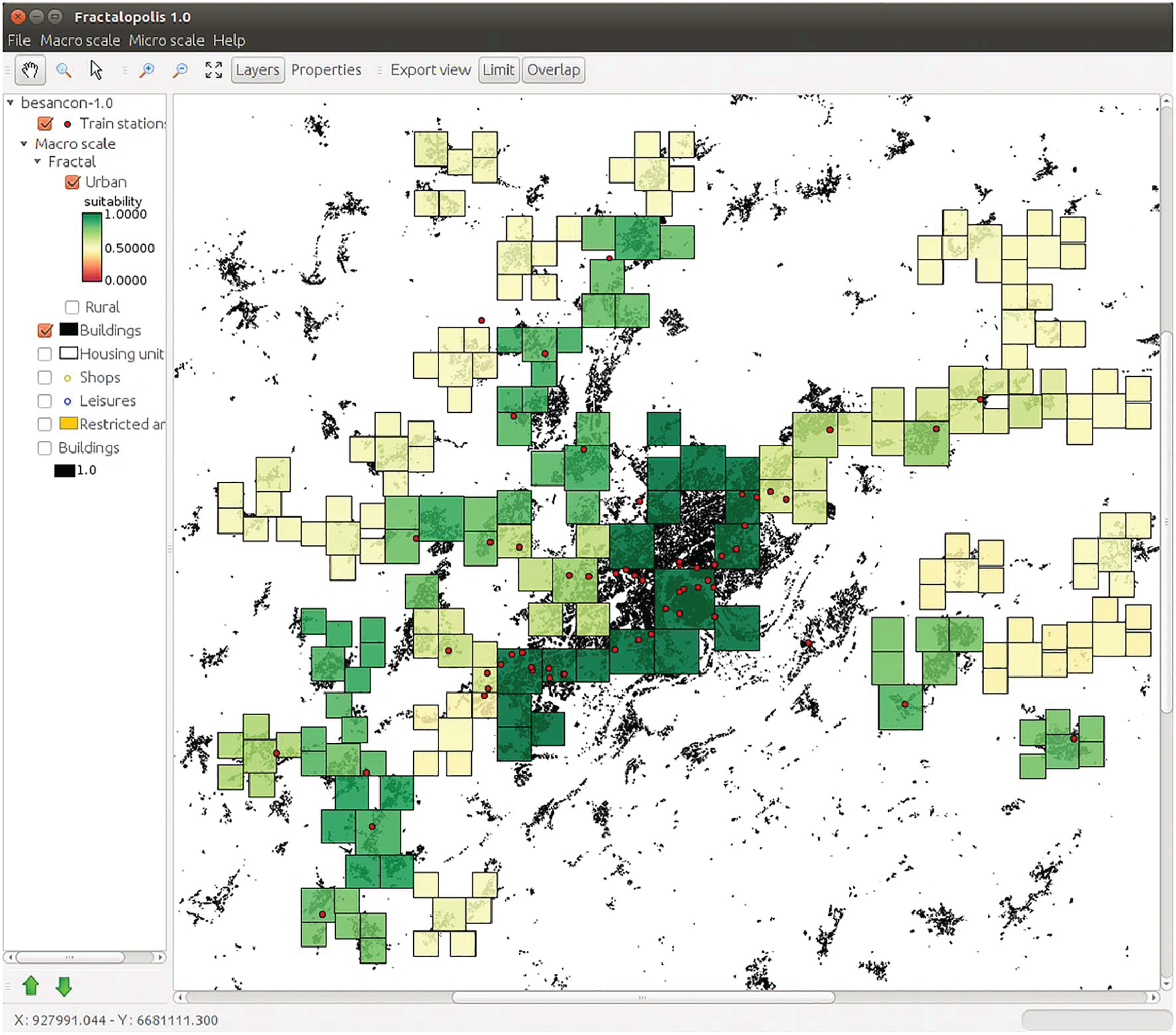
Fractalopolis, the multifractal urban planning model, now published in the journal “Computers, Environment and Urban Systems”
A fifteen pages article synthesizes the planning premises that inspired applying the concept to the Grand Besançon agglomeration, thus outlining the second step of applying fractal models for urban and regional purposes.
Fractalopolis allows conceiving development plans on an urban and regional scale, based on five basic principles: a hierarchized polycentric urban development; a development linked to transportation axes; a locally concentrated development of residential areas avoiding diffuse sprawl, the interpenetration of green areas and urban areas across scales; the preservation of an interconnected network of green and natural areas of different size. The article focusses on the formal frame, which allows integrating all at once these five planning principles. The article starts by introducing the theoretical multifractal planning concept and explains then, more deeply, the software simulation tool, which allows applying the model to real world situations. A detailed description of the different modules and the application to the Great Besançon urban area illustrate the stepwise construction of such a planning scenario. I.) Choosing the central places of different hierarchical order as well as their catchment areas. II.) Evaluation of the performance of these areas with respect to the accessibilities to different types of amenities III.) Analysis and calibration of the spatial configuration of residential development according to the purposes of existing master plans.
- Details
- Category: Award and distinction
Pierre Frankhauser et Claudia Yamu: Winners of the Breheny Prize
The editors of Environment and Planning B would like to announce that the Michael Breheny prize for the best paper published in 2015 has been awarded to Claudi Yamu and Pierre Frankhauser for their paper ‘Spatial accessibility to amenities, natural areas and urban green spaces: using a multiscale, multifractal simulation model for managing urban sprawl’ which was published in the journal in November 2015, vol. 42, no. 6, 1054–1078.
Environment and Planning B: Planning and Design Announcement