- Details
- Category: Publication and Output
Fractalopolis, the multifractal urban planning model, now published in the journal “Computers, Environment and Urban Systems”
A fifteen pages article synthesizes the planning premises that inspired applying the concept to the Grand Besançon agglomeration, thus outlining the second step of applying fractal models for urban and regional purposes.
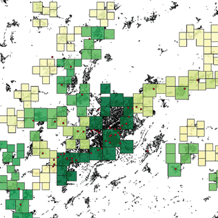
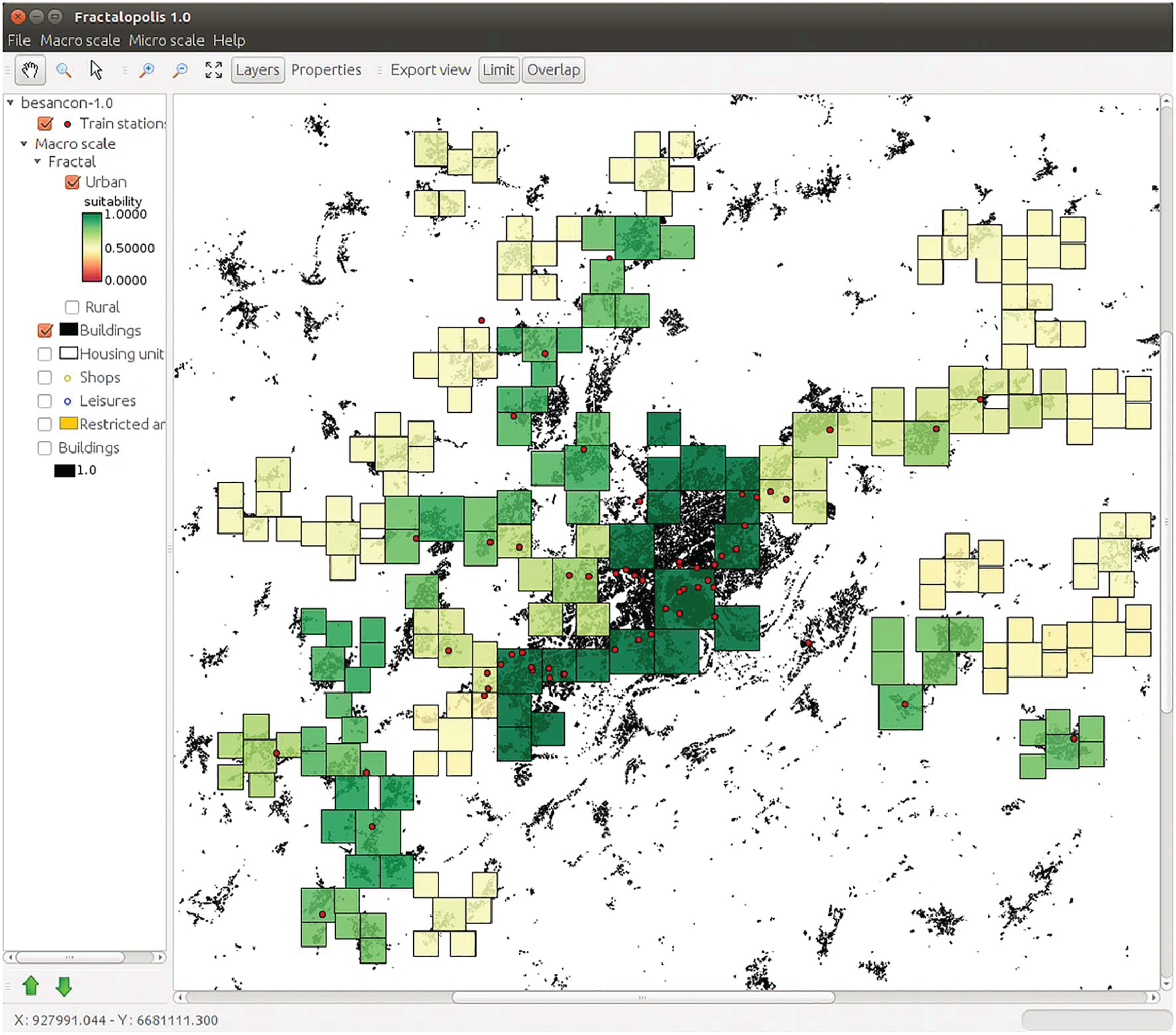
Fractalopolis allows conceiving development plans on an urban and regional scale, based on five basic principles: a hierarchized polycentric urban development; a development linked to transportation axes; a locally concentrated development of residential areas avoiding diffuse sprawl, the interpenetration of green areas and urban areas across scales; the preservation of an interconnected network of green and natural areas of different size. The article focusses on the formal frame, which allows integrating all at once these five planning principles. The article starts by introducing the theoretical multifractal planning concept and explains then, more deeply, the software simulation tool, which allows applying the model to real world situations. A detailed description of the different modules and the application to the Great Besançon urban area illustrate the stepwise construction of such a planning scenario. I.) Choosing the central places of different hierarchical order as well as their catchment areas. II.) Evaluation of the performance of these areas with respect to the accessibilities to different types of amenities III.) Analysis and calibration of the spatial configuration of residential development according to the purposes of existing master plans.

- Details
- Category: Award and distinction
Pierre Frankhauser et Claudia Yamu: Winners of the Breheny Prize
The editors of Environment and Planning B would like to announce that the Michael Breheny prize for the best paper published in 2015 has been awarded to Claudi Yamu and Pierre Frankhauser for their paper ‘Spatial accessibility to amenities, natural areas and urban green spaces: using a multiscale, multifractal simulation model for managing urban sprawl’ which was published in the journal in November 2015, vol. 42, no. 6, 1054–1078.
Environment and Planning B: Planning and Design Announcement
- Details
- Category: Conference
The talk will take place at 14h on monday the 21th november at the ThéMA lab building (3rd floor building D).

Rémi Lemoy
Researcher (Post-doc) at the University of Luxembourg
Publications: https://www.researchgate.net/profile/Remi_Lemoy
Abstract:
In this work we study the profile of land use and population density in European cities with respect to the distance to the city centre. We use the GMES Urban Atlas database, providing a precise description of land use at 5m resolution in the 300 major European urban areas (more than 100.000 inhabitants). We combine this dataset with population density from the Geostat population grid, which covers the whole of European Union with a 1km2 resolution. Population is allocated proportionally to surface and weighted by soil sealing and density classes of the GMES data.
We analyse the evolution with distance to the city centre of population density and of the share of land which is artificial. We analyse the scaling of these curves with respect to city population. We find that land use curves, in particular artificial land uses, tend to scale like the square root of city population. Population curves have roughly exponential shapes, as it has been widely modelled in the literature, although usually not based on land use and soil sealing data. Population curves tend to scale like the city population to a power of roughly 1/3.
These results allow us to propose a simple monocentric description of land use shares and population curves in a representative European city, whose size can be chosen based on the scaling relationships we obtain. This result is especially interesting, and of practical use, for the purpose of calibration and validation of monocentric urban models, that can differentiate (or not) housing from land and include interactions between non-developed and developed land.
- Details
- Category: Dissertation Defence
The defense will take place at the "Salle du Conseil de l’UFR Droit, au rez-de-chaussée du Bâtiment Droit-Lettres de l’Université de Bourgogne" (4 boulevard Gabriel, 21000 DIJON). This work was directed by Thomas Thévenin.
Defense jury
Corinne BLANQUART, Research Director at the IFSTTAR,
Anne BRETAGNOLLE, Professor at the University Paris 1-Panthéon-Sorbonne,
Valérie FACCHINETTI-MANNONE, Associate Professor at the University of Bourgogne-Franche-Comté,
Jordi MARTI-HENNEBERG, Professor at the University of Lleida, Spain
Thomas THEVENIN, Professor at the University of Bourgogne-Franche-Comté
Abstract
The interaction between space and network are frequently questioned in the academic literature, by asking the economical and demographical impacts of a new infrastructure, often studied at the scale of a project. This work aims to investigate the components of the interaction in both large spatial and temporal scales. The hypothesis is that the temporal depth and the national scale could bring new explanations. This work is based on the collect, the exploitation and the analysis of the large spatio-temporal database FRANcE (French Railway Network). It identifies all sections of the network since the 19th century and the population census. This database also contains the traces of the speed, which are novel information for network, and allows the accessibility to become a decisive variable in the explanations.
Rather than acquisition new data with an intensive phase of collect, we aim to build a methodological chain to study the two senses of interaction between space and network. It requires the adaptation of data structuration and analysis. The approach of this thesis consists on the growing modelling of the phenomenon, from the comprehension to formalization of data to the analysis, which requires the use of other disciplines. This work uses the graph theory to investigate the two senses of the relationship. It permits to study the network effect in the long run by diversifying the data to identify spatial and temporal ranges. It permits to study the impact of a pre-existing structure in the morphogenesis of the network, by using a dynamic model of network evolution, between diffusion and hierarchical organization. This work aims to understand the link between space and network, where the methodological tools can be adapted to other networks, other times and actual questioning.
- Details
- Category: Dissertation Defence
The defense will take place at UFR SLHSn rue Chifflet at Besançon on December the 1st 2016 at 14H30. This work was co-directed by Jean-Christophe Foltête and Céline Clauzel.
Defense jury
Marc ANTROP, Professor at the University of Gand,
Jacques BAUDRY, Research Director at the INRA,
Céline CLAUZEL, Associate Professor at the University Paris-Diderot,
Marianne COHEN, Professor at the University Paris-Sorbonne,
Jean-Christophe FOLTÊTE, Professor at the University of Franche-Comté,
Thomas HOUET, Associate researcher at the CNRS,
Abstract
Landscape is both a backdrop to the lives of human populations and a medium for the life cycle of animal species. Landscape changes induced by land-use and land-cover dynamics affect both these dimensions, the one aesthetic, and the other ecological. Because these rationales are usually studied within different disciplines, little research has been done into how the two clash or combine as and when landscape structures change. This work seeks therefore to model the spatial co-evolution of the aesthetic and ecological functions of landscape retrospectively using spatial metrics based on land-cover data. It focuses on changes in the urban fringes of two French cities (Paris and Besançon) over the last 30 years.
The approach attempts first to use land-cover data to model (1) the landscape preferences of a set of individuals and (2) the ecological connectivity of a set of animal species. Drawing on both multivariate statistical analysis and spatial analysis, the core of this work consists in investigating how the two functions have evolved in convergent or divergent ways over time. The results provide fresh insight into the relationship between landscape aesthetics and landscape ecology and raise questions about the value of spatial modelling for a landscape management approach that endeavours to reconcile the preservation of residents’ living environments and the conservation of biodiversity.
- Details
- Category: Dissertation Defence
The defense will take place at "Maison des Sciences de l’Homme de Dijon" (6 esplanade Erasme, 21000 DIJON). This work was co-directed by Thomas Thévenin and Nadège Martiny.
Defense jury
BADARIOTTI Dominique, Professor at the University of Strasbourg
JOSSELIN Didier, Research Director at the CNRS, ESPACE
MARILLEAU Nicolas, Research Engineer at the IRD-UMMISCO, UPMC
MARTINY Nadège, Associate Professor at the University of Bourgogne-Franche-Comté
SANDERS Lena, Research Director at the CNRS, Géographie-Cités
THEVENIN Thomas, Professor at the University of Bourgogne-Franche-Comté
Abstract
Based on surveys, traffic is constructed from assumptions about the relationship between origins and destinations. In order to rebuild a road traffic wich would be closer to observation and on a wider set of road sections, it appears interesting to use counting data from urban sensors : this is our starting point of view. The insertion of these in-situ dataset in the road traffic measurement provides the opportunity to experience the potential of sensors to estimate Traffic Air Pollution (TAP) levels at the intraurban scale. However, this requires to change the nature of these estimation, here through the construction of a model of multi-agents simulation, in order to extract more information on the road traffic. More generally, this work can be seen as a a knowledge building approach on TAP emisssions which is discussed throughout this work.
The implementation of the SCAUP (multi-agent simulation from Urban sensors for traffic air pollution) approach was developped in three stages: 1. Focusing on the quantification of road traffic devices through urban sensors; 2. Proposing a modeling approach for road traffic data simulation ; 3. Using as a reference the national framework used by AASQA to calculate RTA emissions. All is integrated within a technical matrix that forms the spine of the manuscript through three interrelated systems: quantification, modeling and evaluation. This work is part of an experimental approach dedicated to the calculation of TAP emissions based on traffic simulations. Sponsored by the ATMOSF’AIR BOURGOGNE local AASQA, this work could also be used in an operational mode for these organizations in charge of the air quality monitoring. At a time when the big data enters into new questions about the ability of researchers to extract knowledge, we propose a geographical approach that enables to replace the data in the center of an original road traffic simulation approach (data- driven).
- Details
- Category: Publication and Output
 An Interdisciplinary Approach to Residential Choice in its Social Context
This book proposes, from a cross-disciplinary perspective, an original reading of current work on residential choice and the decisions associated with it. Geographers, social-psychologists, economists, sociologists, neurologists and linguists have worked together in the context of collective research into evaluation, choice and decision-making in the use of urban and periurban spaces. A synthetic outlook has been constructed from these complimentary scientific references. The book, which is designed as a handbook, also provides the opportunity to set out the different approaches to deal with the models which have been developed in this field.
http://www.springer.com/us/book/9783658155414#aboutAuthors
About the authors:
Pierre Frankhauser has a doctoral degree in theoretical physics and in geography. He is full professor of geography at the University of Franche-Comté, Besançon.
Dominique Ansel has a doctoral degree in psychology. He is associate professor at the University of Franche-Comté, Besançon.
- Details
- Category: Dissertation Defence
The defense will take place at the Grand Salon, 18 rue Chifflet, Besançon down town. This work was co-directed by Serge Ormaux and Jacques Fontaine.
- Details
- Category: Dissertation Defence
The defense will take place at the thesis room of the "Maison des Sciences de l’Homme" at the University of Burgundy, 14:30, 6 Esplanade Erasme at Dijon.
- Details
- Category: News
Thomas Buhler is invited under the initiative of laboratory Chôros and “PostCarWorld” research project.
http://postcarworld.epfl.ch/page-113202-en.html