- Details
- Category: Dissertation Defence
Claire Regnier is defending her PhD thesis the 14th december 2022 at 14 at the IRTS of Franche-Comté in Besançon.
This work was directed by Alexandre Moine, géographer, professor of University of Franche-Comté and Christian GUINCHARD, sociologist, Senior lecturer at the University of Franche-Comté.
Defense jury :
Erwan Becquemie, Director General of Hygiène Sociale of Franche-Comté
Olivier David, Professor, University of Rennes 2
Philippe Lyet, Sociologist, Askoria, Rennes
Jean-François Thémines, Professor of University of Rennes 2
Abstract :
The thesis project will question the link between social work and territory based on the work of Alexandre Moine, geographer, at the ThéMA laboratory. Three dimensions will be questioned: Social work with the test of the territories. Understand how social work deals with the territorial dimension by questioning the links social work has with the territory. More precisely, how institutions and social workers think, apprehend the territory in the responses they offer to users in their support practices. Territory challenged by social work. How the development of a territory can be anchored in social work. Where exactly is the development of a territory related to social work? Here we can examine the notion of local social development, which aims to be a federative approach aimed at mobilizing actors from a territory around a project that is at the same time economic, institutional, social and cultural. IRTS, training devices in social work in the heart of the territories. Faced with the challenges facing our sector, the IRTS as a training tool for social workers, have an important role to play. Today, the reshaping of social work that starts, the new architecture of diplomas that will change the professional identities must integrate the concept of territory.
- Details
- Category: Dissertation Defence
The defense will take place in Champs-sur-Marne at the Ecole Nationale des Ponts et Chaussées (salle B203) on april the 1rst.
This work was directed by Alain L'Hostis and Pierre Frankhauser.
Funding : Ecole des ponts ParisTech-ENPC / Efficacity-Institut de Recherche & Développement pour la Transition Énergétique de la Ville.
Defense jury :
- Alain L'HOSTIS, Senior researcher, University of Gustave Eiffel
- Pierre FRANKHAUSER, Emeritus professor, University of Franche-Comté
- Olivier BONIN, Senior researcher, University of Gustave Eiffel
- Cristina PRONELLO, Professor Polytechnic of Turin
- Giovanni FUSCO, Director of Research, University of Côte dʹAzur
- Cécile TANNIER, Director of Research, CNRS, University of Franche-Comté
- Morgane COLOMBERT, PhD and ingenior, EFFICACITY
Abstract
Today, the question of energy production and consumption is one of the main points of the sustainable development. However, there is no real reflection about the way to develop energy solutions which can have a high efficiency during and at the end of urban development. The present work wants to conceive urban planning scenarios taking into account urban development evolution and energy network. To answer, a modelling approach is going to be used integrating in particular the concept of fractal. This study is going to be realized on the Est-Ensemble territory.
You will also be able to attend the defense by videoconference : https://univ-eiffel.zoom.us/j/82103219027 - ID de réunion : 821 0321 9027. Mot de passe : Bh6utBNb

- Details
- Category: Diffusion
Cécile Tannier presents the Fractal model and its impact on how urban forms and spatial organisation are approached in urban studies and planning. Reflecting critically on scale invariance and optimality, she shows how and why fractal models enable us to better understand how space is organised through scales and how urban planning can modify this spatial organisation in a fractal manner, accounting for the effects of distance and scale dependence.
See the video on the YouTube channel: https://www.youtube.com/channel/UCbXVD-lwollN5yxX_0J-hbg
- Details
- Category: Dissertation Defence
The defense will take place the 7th december at 14:30 at the "Grand salon", UFR SLHS, 32 rue Megevand in Besancon.
This work was co-directed by Jean-Christophe Foltête (ThéMA) and Stéphane Garnier (Biogéosciences).
Funding: CIFRE thesis with the company ARP-Astrance, Paris
Defense jury
Stéphanie Manel, Professor, EPHE, UMR CEFE, Montpellier
Eric Petit, Director of Research, INRAE, UMR ESE, Rennes
Laurence Després, Professor, Université Grenoble Alpes, UMR LECA, Grenoble
Laurent Bergès, research ingenior, INRAE, UR LESSEM, Saint-Martin-d’Hères
Hervé Moal, ARP-Astrance, Paris
Abstract
Several key ecological processes for maintaining biodiversity rely upon the ecological connectivity of habitat. Accordingly, connectivity modelling methods have been developed for understanding precisely the influence of connectivity and deriving sound biodiversity conservation measures. Among them, landscape graphs represent habitat networks as sets of habitat patches (nodes) connected by potential dispersal paths (links). Yet, the ecological relevance of these tools required validation from biological data reflecting closely the influence of habitat connectivity. Genetic data allow for such validation as population genetic structure partly depends on dispersal-driven gene flow between habitat patches. Genetic structure can also be modelled as a genetic graph whose nodes correspond to populations while its links are weighted by pairwise genetic differentiation measures.
The objective of this PhD project was to bridge landscape and genetic graphs in order to (i) assess the ecological relevance of landscape graphs and (ii) gain knowledge regarding the relationship between habitat connectivity and population genetic structure. After identifying genetic graph construction and analysis methods fitting several research contexts and developing a software package for the joint use of both landscape and genetic graphs, we compared them in two empirical studies. We thereby (i) assessed the respective influence of several components of the habitat connectivity pattern on both genetic diversity and differentiation and (ii) validated the ecological relevance of landscape graphs. We then evidenced that integrating variables deriving from the nodes and links of both types of graphs could improve the inference of the effect of every landscape feature on connectivity. The methods we have developed could find new applications in this field and others. We hope that the results of this thesis will contribute to this.
You will also be able to attend the defense by videoconference :
https://cnrs.zoom.us/j/98316448475?pwd=VjlFWDZ1NWNFb285cC9ZUW1CRGZ1UT09
Code : E9gt9r
- Details
- Category: Diffusion
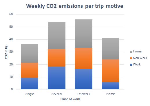
When new lifestyles disrupt daily mobility in England
By exploring data relating to England from the UK National Travel Survey between 2002 and 2017, this research led by Benjamin Motte-Baumvol was able to refine the analysis of daily mobility usually carried out in France (where surveys are based on one “typical day”) by considering the variability of travel over a whole week, which reflects our increasingly fragmented lives more authentically.
Thanks to new “remote” practices enabled by the development of telework and online shopping, we can perform our activities in a greater variety of locations and many trips that were previously necessary are now avoidable. But the organization of our everyday life is becoming more complex and these trends are seemingly leading us to perform more and more carbon-emitting trips.
The purpose of this research is to understand how current evolutions in the lifestyles and working conditions of workers are causing adaptations in daily travel and its coordination within the household. Three dimensions of people’s lifestyles were studied: the influence of the workplace and of teleworking on travel, the effects of online shopping, and finally the determinants of taking children to their activities among dual-income families. The analysis of quantitative data allows us to describe these practices, to understand whether there are interactions between these different activities and see if they make it possible, as one might think regarding digital tools, to reduce travel and associated CO2 emissions.

- Details
- Category: Dissertation Defence
The defense will take place in Dijon at the University of Burgundy on december 14th

This work was directed by Thomas Thevenin, Associate researcher "HDR" ThéMA and Yves Richard, Associate researcher "HDR", Biogéoscience-CRC.
The defense can be followed online by : http://desktop.visio.renater.fr/scopia?ID=727610***8300&autojoin
Code d'accès : 8300 (terminer par #)
Defense jury
Houet Thomas, Director of Research "HDR" CNRS, LETG, Rennes
Masson Valéry, Director of Research HDR, GMME/VILLE, CNRM, Toulouse
Cantat Olivier, Associate researcher, LETG, Caen
Ruas Anne, research ingenior "HDR", IFFSTAR, Marne-la-Vallée
Sanders Léna, Director of research "HDR" CNRS,Géographie-Cité, Paris 1
Abstract
The urban environment is at the crossroads of two complex systems with different temporalities : climate and society. The urban climate is a modification of the climate caused by the presence of a city. The most successful expression of this climate change by the presence of the city is the phenomenon of Urban Heat Island (UHI). In a global context of adaptation and mitigation to climate change and urban development, this phenomenon of ICU tends to increase, and its health impacts on populations to become more prominent. This work is aimed at improving the knowledge of the impact of urban form and urban development on the intensity of the UCI through the implementation of a decision support tool allowing to integrate urban climate into decision-making processes. To do this, a “ model-dependent ” approach has been adopted. Five urban growth scenarios are based on the same number of housing but correspond to different Local Climate Zones (Grouped individual housing - LCZ 9, Individual group housing - LCZ 6, Low density collective - LCZ 3, Collective - LCZ 2, Dense collective - LCZ 4). These are developed by 2050, based on input data from growth models (MUP-City) and urban climate (Meso-NH / TEB). In order to assess the ability of Meso-NH / TEB to reproduce temperatures in Dijon Métropole, a control simulation, relating to the current city, is previously compared with data from the MUSTARDijon network for the heat wave period from 22 to 26 July 2018. A comparison of the results with the MUSTARDijon textit in situ network shows that the simulated temperatures are spatially and temporally consistent with the observations. The diurnal cycle is correctly modeled as well as urban and rural environments. A significant bias is present at nights in rural areas where temperatures remain high, limiting the intensity of the simulated UI. Compared to the control simulation, for the days (12LT to 18LT), the scenario with LCZs 3 and 2 present warmer temperatures than the scenario with LCZs 9 and 6. The scenarios for which the building percentage is the smallest has the smallest temperature increases. Finally, it would seem that building, whatever the urban form, on the outskirts of already defined built-up areas, has little impact on their temperature.
- Details
- Category: Dissertation Defence
François Sémécurbe is defending his PhD thesis : Analysis of the spatial distribution of human settlements : Contributions and limitations of multi-scale and trans-scale indicators
The defense will take place in Besançon at the University of Franche-Comté at Salon Préclin, UFR SLHS on september 25th at 2 pm.
This work was directed by Cécile Tannier, Senior researcher at CNRS (French National Centre for Scientific Research).
Defense jury
Elsa Arcaute - Associate professor, CASA, University College London
Giovanni Fusco - Associate researcher "HDR" at CNRS, laboratory ESPACE, Nice
Didier Josselin - Director of Research CNRS, laboratory ESPACE, Avignon
Julien Perret - Director of Research LASTIG, Paris
Pierre Frankhauser - Emeritus Professor at the University of Franche-Comté, laboratory ThéMA
Stéphane Roux - Lecturer – HDR, ENS de Lyon, laboratory of physics
Abstract
As human beings, it is easy for us to judge visually whether a distribution is dispersed or concentrated. However, the quantitative formalization of our impressions is problematic. It depends on the scales of the chosen analysis. This dependence of indicators on scales has changed. It is initially considered as a barrier to knowledge, it now reflects the multi-scale organisation of the distributions studied. The central objective of this thesis is to investigate the limits and contribution of multi-scale and trans-scale indicators to the study of the spatial distributions of human settlements. Spatial analysis aims at comparing spatial distributions to a uniform distribution. The way in which spatial distributions move away from this reference is used to characterize the multi-scale organization of the analyzed distributions. The application of these methods to human settlements has not been satisfactory. The use of an exogenous reference is not adapted to distributions that are very unevenly concentrated in space. Fractal analysis used in urban geography considers that the analysed distributions are their own measurement standard. Fractal dimensions measure how the space occupied by them evolves across scales. This type of analysis requires a regularity between scales, the invariance of scale whose existence is not verified on all territories. Trans-scale analysis generalises the principles of fractal analysis to all distributions and makes it possible to characterise the unequal concentration of human settlements in rural and urban territories.
- Details
- Category: Dissertation Defence
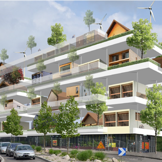
Jean Houssemand is defending his PhD thesis : Conceptualization and evaluation of a typology of vertical housing concept for sustainable urban planning
The defense will take place in Dijon at the University of Burgundia at the Maison des Sciences de l'Homme, Salle des Thèses (6 Esplanade Erasme), on february 14th at 14pm.
This work was directed by Jean-Philippe Antoni, Professor at the University of Burgundy, laboratory ThéMA.
Defense jury
Denis Bocquet, Professor at the National School of Architecture of Strasbourg
Éric Charmes, Director of Research at the Laboratory for interdisciplinary research on cities, spaces and society (EVS RIVES), Graduate School of Civil, Environmental and Urban Engineering, Vaulx-en-Velin
Pierre Frankhauser, Emeritus Professor at the University of Franche-Comté
Hélène Haniotou, Professor at the National Technical University of Athens, Greece
Abstract
Context. The current urban development process is the result of a paradoxical situation. On the one end, families prefer individual housing, which finds the favourable conditions to its spreading in the more or less distant from towns outskirts, while wishing to benefit from services (proximity to amenities, public transport offers, etc.) which are rather the corelate of dense urban centralization. On the other hand, in order to fight against environmental, social and economic costs of urban sprawl, and also aim towards a more sustainable city, the urban renovation and compact city projects lead to some density levels that only collective housing enables to reach.
Problematic. So, the equation « control of the urban sprawl, satisfaction of the house request and sustainable city » seems to be unsolvable, especially due to the lack of a housing offer being able to combine the particularities of the detached house and the needs of urban density. Two relatively separate tandems « housing / territory and induced mobility » result from it : individual housing, which is dependent on cars, is mainly situated in peri-urban areas, whereas collective housing, which is not approved by most families, gather in the town centers with many alternatives to cars. In such a context, through the main concept of « vertical housing development », this doctoral research work arises the hypothesis that the enlargement of the prism of the mobilities and urban areas analysis should enable the emergency of new solutions, which will include the housing and territories specifications in a multidisciplinary and multiscale way.
Methodology. In order to confirm this hypothesis, the methodology hinges on two steps. First, a review of the architectural literature allowed to define the « vertical housing concept » as an innovative answer to the equation which is insolvable nowadays : indeed, the history of architecture informs us profusely on the opportunities of a vertical urbanism unexploited until now ; this enables the creation of hanging artificial grounds to build in floors detached houses. In second place, the state of the art allowed to identify the main determinants of housing attractiveness while confronting the two classical tandems (individual/collective) to the concept of « vertical housing development » and suggests a theoretical model adaptable to different cases. Validation. The model has been evaluated three times. Firstly, the information gathered during a photo-elicitation inquiry allow to validate the architectural choices a posteriori and make sure of their suitability in terms of residential preferences (social validation). Secondly, a legal evaluation shows that a development of the current regulatory measures is indeed partially necessary to the operational development of the model, but the latter can nevertheless quickly fulfill the demand while fighting against urban sprawl. Thirdly, a geographical evaluation which compares the deployment of the model with the reality of available grounds and the localization of amenities and transport infrastructure, shows that it would concretely allow to densify the town and its outskirts according to a logic close to the Transit Oriented Development (TOD). Results. Three major results arise from this evaluation. Indeed, the « vertical housing development » concept seems (i) to match with the residential choices from a significant part of the French families, (ii) to be immediately authorized and managed by the current legal and regulatory framework, (iii) to benefit from a consequent potential of development at the level of the Strasbourg-Eurometropolis which serves as an example to this thesis. Moreover, at a time when multidisciplinary and multiscale approaches are questioned, this thesis work, which links an architectural approach at the housing level and a geographical approach at the city level, gives a specific example of new types of housing formalization, based on the original principle of a decoupling between « housing types » and « territories ».
Keywords : Housing types, Housing concept, Urban form, Urban renewal, Compact city, Sustainable city, Evaluation, Modelization, Multidisciplinarity, Multiscalarity
- Details
- Category: Dissertation Defence
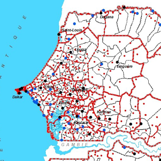
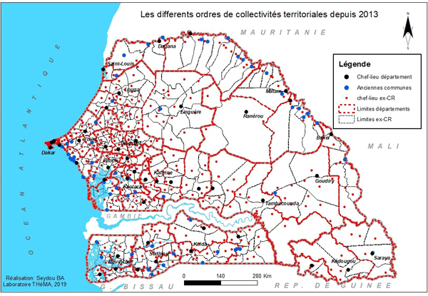
Seydou Ba is defending his PhD thesis : The issue of viability and socio-economic development in institutional territories facing administrative divisions in Senegal
The defense will take place in Besançon at the Salon Preclin, UFR SLHS on decembre 16th at 10am.
This work was directed by Alexandre Moine, Professor at the University of Franche-Comté, laboratory ThéMA.
Defense jury
Frédéric Giraut, Professor at the University of Geneva, Switzerland
Jean-Christophe Gay, Professor at the University of Sophia-Antipolis, Nice, France
Stéphanie Lima, Lecturer at the INU Champollion, Albi, France
Abdourahmane Sene, Lecturer at the University of Assane Seck de Ziguinchor and Director of spatial planning of the Ministery of « Gouvernance territoriale, du Développement et de l’Aménagement du Territoire », Senegal
Christian Guinchard, Lecturer – HDR at the University of Franche-Comté, France
Abstract
The purpose of this thesis is to analyze the process of construction and delimitation of communal territories in Senegal. Indeed, in Senegal, the communes constitute the basic territorial collectivities. They have legal personality and financial autonomy. They are created by decree, which must be concretely translated into a territorial division.
During the first years of 2000, the steady pace of administrative divisions led to a rapid change in the territorial organization and in parallel to the number of territorialized actors. This dynamic of recomposition then provoked a lively debate on the underpinnings of the divisions and the relevance of the territorial entities. This situation is all the more worrying as a number of conflicts between local and regional authorities have become widespread.
However, the creation of new territories in Senegal is very rarely accompanied by a materialization of their spatial limits. This phenomenon creates a great deal of uncertainty around the boundary and causes various conflicts that hinder the management and development of communities whose physical territory remains more or less poorly known.
It is in this context that we are interested in the process of administrative divisions to understand how territorial boundaries are defined and set up? What roles do they play in the management, ownership, cohesion and development of the territories they contribute to create and of which they constitute a determining component? What is the real existence of these territories? What do they represent for the actors? It is to these concerns that this thesis has tried to answer, through the example of 5 communes in the Saint-Louis region.
This research was conducted on the basis of a systemic approach, the conduct of semi-structured interviews and the use of mind maps. The goal is to analyze and understand the complex process of building boundaries and territories.
For data processing and analysis, we used a method of empirical analysis of content in order to understand the different spatial reference scales of the actors; the process of creating municipalities; the actors involved and their roles; finally, their level of appropriation of the communal territories.
- Details
- Category: Publication and Output
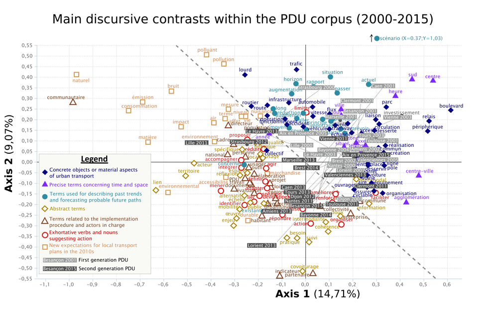
An interdisciplinary research work between urban planning and language sciences now published in the journal Urban Studies
Thomas Buhler, laboratory ThéMA and Virgnie Lethier, ELLIADD (University of Franche-Comté) present a new method which opens up research perspectives for the coming years.
For several decades now, French cities - like many others around the world - regularly publish urban planning documents in which their strategies are expressed for the next 5, 10 or even 15 years. These documents concern particular themes (transport, land use regulations, housing, etc.). Begun two years ago, an interdisciplinary project between research centres ThéMA and ELLIADD focuses on the analysis of the these 'planning discourses', based on textometry, a reproducible method of textual data analysis. This systematic method aims to overcome certain methodological and technical obstacles present in the field of urban policy discourse analysis, which is often based on interpretative methods that are weakly reproducible or documented.
Buhler, T., & Lethier, V. (2019). Analysing urban policy discourses using textometry: An application to French urban transport plans (2000–2015). Urban Studies. https://doi.org/10.1177/0042098019873824